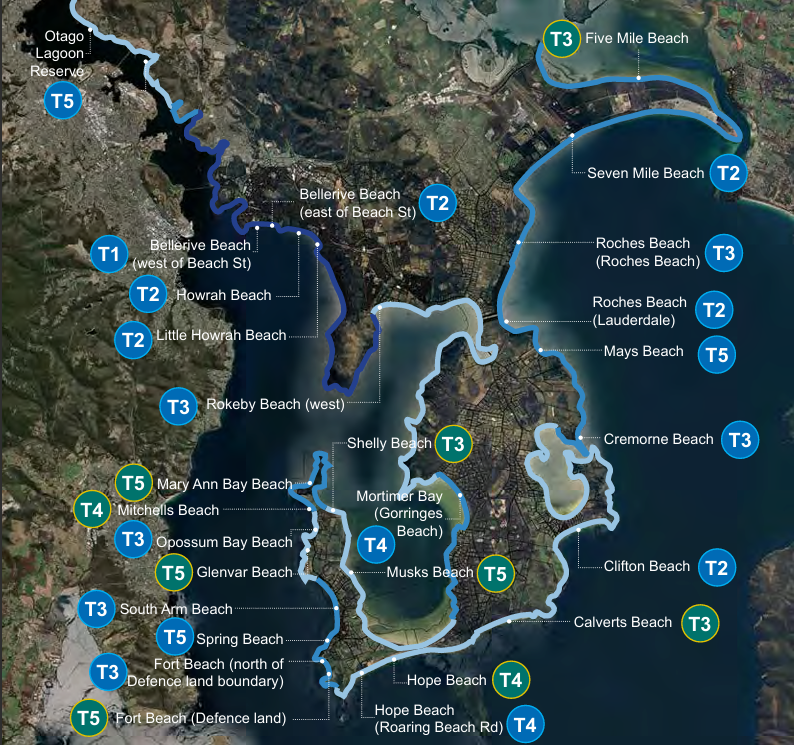
What are they?
What are tier classifications?
Not every spot can be highly accessible, and that’s OK. We aim for a good mix across the coastline so people can connect with the coast in different ways. To do this, coastal locations are assessed and categorised into the site's accessibility potential.
We look at a site’s accessibility potential using five things:
- Existing conditions: terrain, coastal processes, and any current access features.
- Location and users: how close it is to homes, town centres and transport, how popular it is now, and how many more people could visit if barriers were removed.
- Usage: what people do there (for example, walking, swimming, fishing) and what gear they bring (prams, mobility aids).
- Community expectations: what locals say is missing and how they want to use the place.
- Maintenance: the level of service the land manager can realistically provide.
How this guides action
We follow a simple method:
site audit
↓
analysis
↓
identify issues and opportunities
↓
community and stakeholder input
↓
assign a rating
↓
list site opportunities for future works.
This gives us a clear, consistent way to plan upgrades and advocate for you with other land managers.
Your feedback in our Phase 1 Consultation allowed us to assign ratings to the sites and create a list of site opportunities. In this consultation, we want to know if you agree with our assessment.
Beaches and coastlines
Beaches and coastlines get a rating from T1 to T5:
- T1 = Optimal Accessibility (the highest level of access)
- T5 = Minimal Accessibility (basic access only)
Each level sets what visitors can typically expect. The rating helps match designs to the place and guides where investment will have the biggest benefit.
| Classification | Type Description | Typical Features | Potential Additional Features |
|---|---|---|---|
| T1: Optimal Accessibility |
Highest level of physical and visual access and supporting infrastructure provided. Caters to broadest range of users and accessibility needs. Supports visiotrs to stay for longer periods of time. |
• Accessible parking • DDA compliant ramp access to the beach • DDA compliant step access to the beach • Level beach access paths with firm surfacing • Lookout and/or coastal viewing points • Accessible toilets • Beach shower and/or foot wash station • Seating • Shade and weather shelters • Continuous path of travel between key arrival and destination points • Water bottle filling • Bins |
• Beach access mat • Beach wheelchair for hire/loan • Changing Places facility • Hot water showers • Change room facility • Lighting • Trip planning information (eg. Site maps, Social stories, website) • Wayfinding signage • Nearby to food/kiosk services • Public transport connections • Swim extending facility (eg. lap buoys, swim pontoon) • Kayak and small vessel wash down facility |
| T2: Highly Accessible |
High level of physical and visual access and supporting infrastructure. Caters to broad range of users and accessibility needs |
• Accessible parking • DDA compliant step access to the beach • Level beach access path/s with firm surfacing • Lookout and/or coastal viewing points • Accessible toilets • Seating • Shade and weather shelters • Continuous path of travel between key arrival and destination points • Bins |
• DDA-compliant ramp access to the beach • Beach shower and/or foot wash station • Change room facility • Water bottle filling • Beach access mat • Trip planning information (eg. Site maps, Social stories, website) • Wayfinding signage • Public transport connections • Swim extending facility (eg. lap buoys, swim pontoon) • Kayak and small vessel wash down facility |
| T3: Moderately Accessible |
Moderate level of physical and visual access and supporting infrastructure. Caters to a range of users and accessibility needs to make use of some facilities and activities. |
• Carparking • Step access to the beach • Level beach access path/s with firm surfacing • Lookout and/or coastal viewing points • Seating • Bins |
• Accessible parking • DDA compliant step access to the beach • Accessible toilets • Shade and weather shelters • Continuous path of travel between key arrival and destination points |
| T4: Limited Accessibility |
Limited level of physical and visual access and supporting infrastructure. Caters to a limited range of users and accessibility needs. |
• Carparking • Step access to the beach |
• Level beach access path/s with firm surfacing • Lookout and/or coastal viewing points • Seating • Continuous path of travel between key arrival and destination points • Bins |
| T5: Minimal Accessibility |
Minimal level of access, catering to the least range of users and accessibility needs. | • Step access to the beach |
• Carparking |
Beaches and coastline classifications
The majority of T1 - T3 beaches were given to beaches managed by City of Clarence, so improvements can be planned and delivered more easily.
| Classification | Managed by Council | Managed by Others |
|---|---|---|
| T1 | Bellerive Beach (west of Beach Street) | |
| T2 |
Bellerive Beach (east of Beach Street) Howrah Beach Little Howrah Beach Roches Beach (Lauderdale) Seven Mile Beach (to plane watching area) Clifton Beach |
|
| T3 |
Roches Beach (Roches Beach) South Arm Beach Opossum Bay Beach Cremorne Beach Fort Beach (north of Defence land boundary) Rokeby Beach (west) |
|
| T4 |
Hope Beach (Roaring Beach Road) Mortimer Bay (Gorringes Beach) |
Hope Beach Mitchells Beach |
| T5 |
Spring Beach (73-93 Blessington Street) Mays Beach Otago Lagoon Reserve |
Mary Ann Bay Beach Glenvar Beach Fort Beach (Defence land) Musks Beach |
| Excluded |
Richardsons Beach Huxleys Beach |


